
By Trails Programs Manager & Data Scientist, Brian Greene Saturday June 1 was this year’s National Trails Day. Started by the American Hiking Society, National Trails Day (NTD) celebrates any muscle-powered activity on trails the…
The D&L Blog National Trails Day

Archive for: National Trails Day posts
Continue Reading

Individuals are notoriously bad about making predictions because we have biases and poor memories. The great thing about data is that it can show new insights and challenge preconceived beliefs.
This May will complete 5 full years of programming for Get Your Tail on the Trail and we’re celebrating our nationally-recognized program in big ways all year long!
Post by: Danielle Wolfrum, D&L Advancement Officer There are many reasons to become a member of the D&L this June, not only does your membership support all the work we do on the trail, at…
Post by: Terri Monserrat, Communications & Education Coordinator You check the weather, pack everything you need to get you through the day, double and triple check your emergency supplies, layer your clothing for the conditions,…

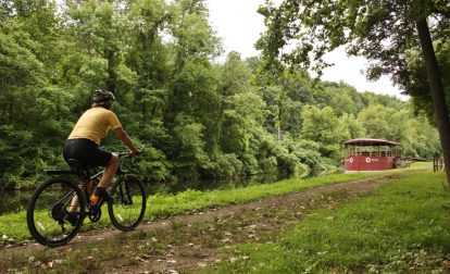
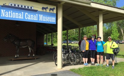
Staff members and volunteers of the Delaware and Lehigh National Heritage Corridor will lead two guided “Preview the Trail” bicycle rides on new portions of the D&L Trail in Lehigh and Carbon counties on National…
On June 5, the D&L held its annual National Trails Day (NTD) event at Carbon County’s D&L Trailhead in Jim Thorpe. Pennsylvania Speaker of the House Keith McCall, a long-time friend of the trail, was…
On Saturday, hundreds of trail users, including members of the press, braved the 95 degree conditions to attend the unveiling of our directional blades, listen to project updates, and help install mile markers, all as…
Although we can estimate the length of D&L Trail sections using river mile charts and topographical maps, there is no substitute for walking the trail with a surveying wheel and taking GPS readings. This is…
Archives
- Jun 2026
- May 2026
- Apr 2026
- Mar 2026
- Feb 2026
- Jan 2026
- Dec 2025
- Nov 2025
- Oct 2025
- Sep 2025
- Aug 2025
- Jul 2025
- Jun 2025
- May 2025
- Apr 2025
- Mar 2025
- Feb 2025
- Dec 2024
- Nov 2024
- Oct 2024
- Sep 2024
- Aug 2024
- Jul 2024
- Jun 2024
- May 2024
- Apr 2024
- Mar 2024
- Feb 2024
- Jan 2024
- Dec 2023
- Nov 2023
- Oct 2023
- Sep 2023
- Aug 2023
- Jul 2023
- Jun 2023
- May 2023
- Apr 2023
- Mar 2023
- Feb 2023
- Jan 2023
- Dec 2022
- Nov 2022
- Oct 2022
- Sep 2022
- Aug 2022
- Jul 2022
- Jun 2022
- May 2022
- Apr 2022
- Mar 2022
- Feb 2022
- Jan 2022
- Dec 2021
- Nov 2021
- Oct 2021
- Sep 2021
- Aug 2021
- Jul 2021
- Jun 2021
- May 2021
- Apr 2021
- Mar 2021
- Feb 2021
- Jan 2021
- Dec 2020
- Nov 2020
- Oct 2020
- Sep 2020
- Aug 2020
- Jul 2020
- Jun 2020
- May 2020
- Apr 2020
- Mar 2020
- Feb 2020
- Jan 2020
- Dec 2019
- Nov 2019
- Oct 2019
- Sep 2019
- Aug 2019
- Jun 2019
- May 2019
- Apr 2019
- Mar 2019
- Feb 2019
- Jan 2019
- Dec 2018
- Nov 2018
- Oct 2018
- Sep 2018
- Aug 2018
- Jul 2018
- Jun 2018
- May 2018
- Apr 2018
- Mar 2018
- Feb 2018
- Dec 2017
- Nov 2017
- Oct 2017
- Sep 2017
- Aug 2017
- Jul 2017
- Jun 2017
- May 2017
- Apr 2017
- Mar 2017
- Feb 2017
- Jan 2017
- Nov 2016
- Oct 2016
- Sep 2016
- Aug 2016
- Jul 2016
- Jun 2016
- May 2016
- Apr 2016
- Mar 2016
- Feb 2016
- Jan 2016
- Nov 2015
- Oct 2015
- Sep 2015
- Aug 2015
- Sep 2014
- Aug 2014
- Jul 2014
- Jun 2014
- May 2013
- Apr 2013
- Jan 2013
- Oct 2012
- Sep 2012
- Aug 2012
- Jul 2012
- Jun 2012
- May 2012
- Apr 2012
- Mar 2012
- Feb 2012
- Dec 2011
- Nov 2011
- Oct 2011
- Sep 2011
- Aug 2011
- Jul 2011
- Jun 2011
- May 2011
- Apr 2011
- Mar 2011
- Feb 2011
- Jan 2011
- Dec 2010
- Nov 2010
- Oct 2010
- Sep 2010
- Aug 2010
- Jul 2010
- Jun 2010
- May 2010
- Apr 2010
- Mar 2010
- Feb 2010
- Jan 2010
- Dec 2009
- Nov 2009
- Oct 2009
- Sep 2009
- Aug 2009
- Jul 2009
- Jun 2009
- May 2009
- Apr 2009
- Mar 2009
- Feb 2009
- Jan 2009
- Dec 2008
- Nov 2008
- Oct 2008
- Sep 2008
- Aug 2008
- Jul 2008
- Jun 2008
- May 2008
- Apr 2008


