
by Imogen Wirth-Granlund, D&L Program Coordinator Join us in making your New Year’s Resolution to traverse the D&L Trail’s three regions in 2022: Delaware Canal, Lehigh Valley, and Anthracite. Whether you’re biking, hiking, walking, rolling, snowshoeing, or skiing, get your tail on the trail to…
The D&L Blog Take a Hike!

Archive for: Take a Hike! posts
Continue Reading
By Brian Greene –Trail Programs Manager My favorite part of my job is getting to talk with trail users about the D&L Trail. It’s an amazing trail that has great places to walk, run, or…

There’s always something to do along all 165 miles of the D&L National Heritage Corridor. Head out on the D&L Trail or another Corridor trail. Check out the top trails or parks with trails to…
Post by: Lauren Drabenstott, D&L Marketing Intern Exploring the D&L means more than biking, running, walking, and hiking. The National Heritage Corridor, with towns and trails alike, has pastimes for a day, a weekend, or an…

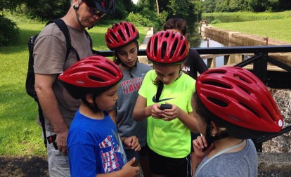
Blog Post By: Terri Monserrat, Communications & Outreach Coordinator Wamer weather means busier trails! Follow our trail etiquette tips to make sure everyone feels welcome on the D&L Trail! Share the trail! Yield to the right,…
Blog Post By: Terri Monserrat, D&L Communications & Outreach Coordinator It may seem like group activities on the D&L Trail occur infrequently in the winter, but there are plenty of places to look for fun outings….

Post by: Claire Sadler, D&L Director, Trails & Conservation I tend to be categorized as a busy, always on the move person but ironically, that means I have to try harder to reserve time for exercise….
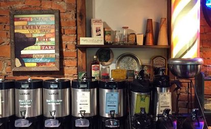
Blog Post By: Terri Monserrat, Communications & Education Coordinator Did you know that Thomas Jefferson called coffee “the favorite drink of the civilized world?” When it comes to important drinks of U.S. history, coffee just…
Post by: Danielle Wolfrum, D&L Advancement Officer There are many reasons to become a member of the D&L this June, not only does your membership support all the work we do on the trail, at…
Guest post by: Mike Burnside, D&L Board Member Since you are viewing the D&L web site, it is very likely that you know what “geocaching” is all about, because people who love geocaching also love…

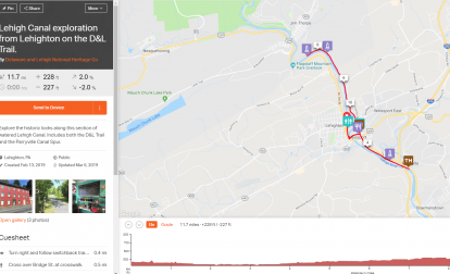
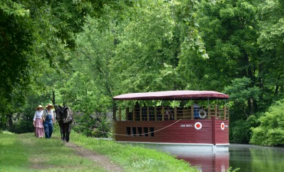
Written by Silas Chamberlin Our “Take a Hike!” series periodically features a favorite day hike or bike on the D&L Trail. The fifth installment is a trip on the very-popular Walnutport section of the Lehigh…
Written by Silas Chamberlin Our “Take a Hike!” series periodically features a favorite day hike or bike on the D&L Trail. The fourth installment is a loop hike or bike on the towpaths of the…
Archives
- Jun 2026
- May 2026
- Apr 2026
- Mar 2026
- Feb 2026
- Jan 2026
- Dec 2025
- Nov 2025
- Oct 2025
- Sep 2025
- Aug 2025
- Jul 2025
- Jun 2025
- May 2025
- Apr 2025
- Mar 2025
- Feb 2025
- Dec 2024
- Nov 2024
- Oct 2024
- Sep 2024
- Aug 2024
- Jul 2024
- Jun 2024
- May 2024
- Apr 2024
- Mar 2024
- Feb 2024
- Jan 2024
- Dec 2023
- Nov 2023
- Oct 2023
- Sep 2023
- Aug 2023
- Jul 2023
- Jun 2023
- May 2023
- Apr 2023
- Mar 2023
- Feb 2023
- Jan 2023
- Dec 2022
- Nov 2022
- Oct 2022
- Sep 2022
- Aug 2022
- Jul 2022
- Jun 2022
- May 2022
- Apr 2022
- Mar 2022
- Feb 2022
- Jan 2022
- Dec 2021
- Nov 2021
- Oct 2021
- Sep 2021
- Aug 2021
- Jul 2021
- Jun 2021
- May 2021
- Apr 2021
- Mar 2021
- Feb 2021
- Jan 2021
- Dec 2020
- Nov 2020
- Oct 2020
- Sep 2020
- Aug 2020
- Jul 2020
- Jun 2020
- May 2020
- Apr 2020
- Mar 2020
- Feb 2020
- Jan 2020
- Dec 2019
- Nov 2019
- Oct 2019
- Sep 2019
- Aug 2019
- Jun 2019
- May 2019
- Apr 2019
- Mar 2019
- Feb 2019
- Jan 2019
- Dec 2018
- Nov 2018
- Oct 2018
- Sep 2018
- Aug 2018
- Jul 2018
- Jun 2018
- May 2018
- Apr 2018
- Mar 2018
- Feb 2018
- Dec 2017
- Nov 2017
- Oct 2017
- Sep 2017
- Aug 2017
- Jul 2017
- Jun 2017
- May 2017
- Apr 2017
- Mar 2017
- Feb 2017
- Jan 2017
- Nov 2016
- Oct 2016
- Sep 2016
- Aug 2016
- Jul 2016
- Jun 2016
- May 2016
- Apr 2016
- Mar 2016
- Feb 2016
- Jan 2016
- Nov 2015
- Oct 2015
- Sep 2015
- Aug 2015
- Sep 2014
- Aug 2014
- Jul 2014
- Jun 2014
- May 2013
- Apr 2013
- Jan 2013
- Oct 2012
- Sep 2012
- Aug 2012
- Jul 2012
- Jun 2012
- May 2012
- Apr 2012
- Mar 2012
- Feb 2012
- Dec 2011
- Nov 2011
- Oct 2011
- Sep 2011
- Aug 2011
- Jul 2011
- Jun 2011
- May 2011
- Apr 2011
- Mar 2011
- Feb 2011
- Jan 2011
- Dec 2010
- Nov 2010
- Oct 2010
- Sep 2010
- Aug 2010
- Jul 2010
- Jun 2010
- May 2010
- Apr 2010
- Mar 2010
- Feb 2010
- Jan 2010
- Dec 2009
- Nov 2009
- Oct 2009
- Sep 2009
- Aug 2009
- Jul 2009
- Jun 2009
- May 2009
- Apr 2009
- Mar 2009
- Feb 2009
- Jan 2009
- Dec 2008
- Nov 2008
- Oct 2008
- Sep 2008
- Aug 2008
- Jul 2008
- Jun 2008
- May 2008
- Apr 2008


